| Algeria Table of Contents
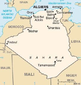 Algeria comprises 2,381,741 square kilometers, more than four-fifths
of which is desert. Its Arabic name, Al Jazair (the islands), is
believed to derive from the rocky islands along the Mediterranean
coastline. The northern portion, an area of mountains, valleys, and
plateaus between the Mediterranean Sea and the Sahara Desert, forms an
integral part of the section of North Africa known as the Maghrib. This area includes Morocco, Tunisia, and the
northwestern portion of Libya known historically as Tripolitania. Algeria comprises 2,381,741 square kilometers, more than four-fifths
of which is desert. Its Arabic name, Al Jazair (the islands), is
believed to derive from the rocky islands along the Mediterranean
coastline. The northern portion, an area of mountains, valleys, and
plateaus between the Mediterranean Sea and the Sahara Desert, forms an
integral part of the section of North Africa known as the Maghrib. This area includes Morocco, Tunisia, and the
northwestern portion of Libya known historically as Tripolitania.
The Tell
The High Plateaus and
the Saharan Atlas
Northeastern Algeria
The Sahara
Climate and Hydrology
Terrain
Source: U.S. Library of Congress
|
