| Bangladesh Table of Contents
Roughly 80 percent of the landmass is made up of fertile alluvial lowland called the Bangladesh Plain. The plain is part of the larger Plain of Bengal, which is sometimes called the Lower Gangetic Plain. Although altitudes up to 105 meters above sea level occur in the northern part of the plain, most elevations are less than 10 meters above sea level; elevations decrease in the coastal south, where the terrain is generally at sea level. With such low elevations and numerous rivers, water--and concomitant flooding--is a predominant physical feature. About 10,000 square kilometers of the total area of Bangladesh is covered with water, and larger areas are routinely flooded during the monsoon season. The only exceptions to Bangladesh's low elevations are the Chittagong Hills in the southeast, the Low Hills of Sylhet in the northeast, and highlands in the north and northwest. The Chittagong Hills constitute the only significant hill system in the country and, in effect, are the western fringe of the northsouth mountain ranges of Burma and eastern India. The Chittagong Hills rise steeply to narrow ridge lines, generally no wider than 36 meters, 600 to 900 meters above sea level. At 1,046 meters, the highest elevation in Bangladesh is found at Keokradong, in the southeastern part of the hills. Fertile valleys lie between the hill lines, which generally run north-south. West of the Chittagong Hills is a broad plain, cut by rivers draining into the Bay of Bengal, that rises to a final chain of low coastal hills, mostly below 200 meters, that attain a maximum elevation of 350 meters. West of these hills is a narrow, wet coastal plain located between the cities of Chittagong in the north and Cox's Bazar in the south. About 67 percent of Bangladesh's nonurban land is arable. Permanent crops cover only 2 percent, meadows and pastures cover 4 percent, and forests and woodland cover about 16 percent. The country produces large quantities of quality timber, bamboo, and sugarcane. Bamboo grows in almost all areas, but high-quality timber grows mostly in the highland valleys. Rubber planting in the hilly regions of the country was undertaken in the 1980s, and rubber extraction had started by the end of the decade. A variety of wild animals are found in the forest areas, such as in the Sundarbans on the southwest coast, which is the home of the worldfamous Royal Bengal Tiger. The alluvial soils in the Bangladesh Plain are generally fertile and are enriched with heavy silt deposits carried downstream during the rainy season. 
Custom Search
Source: U.S. Library of Congress |
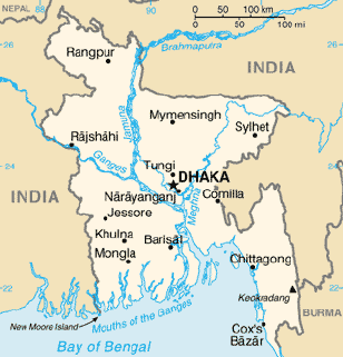 The physiography of Bangladesh is characterized by two distinctive
features: a broad deltaic plain subject to frequent flooding, and a
small hilly region crossed by swiftly flowing rivers. The country has an
area of 144,000 square kilometers and extends 820 kilometers north to
south and 600 kilometers east to west. Bangladesh is bordered on the
west, north, and east by a 2,400-kilometer land frontier with India and,
in the southeast, by a short land and water frontier (193 kilometers)
with Burma. On the south is a highly irregular deltaic coastline of
about 600 kilometers, fissured by many rivers and streams flowing into
the Bay of Bengal. The territorial waters of Bangladesh extend 12
nautical miles, and the exclusive economic zone of the country is 200
nautical miles.
The physiography of Bangladesh is characterized by two distinctive
features: a broad deltaic plain subject to frequent flooding, and a
small hilly region crossed by swiftly flowing rivers. The country has an
area of 144,000 square kilometers and extends 820 kilometers north to
south and 600 kilometers east to west. Bangladesh is bordered on the
west, north, and east by a 2,400-kilometer land frontier with India and,
in the southeast, by a short land and water frontier (193 kilometers)
with Burma. On the south is a highly irregular deltaic coastline of
about 600 kilometers, fissured by many rivers and streams flowing into
the Bay of Bengal. The territorial waters of Bangladesh extend 12
nautical miles, and the exclusive economic zone of the country is 200
nautical miles.