| Cambodia Table of Contents
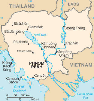 Cambodia covers 181,040 square kilometers in the southwestern part of
the Indochina peninsula. It lies completely within the tropics; its
southernmost points are only slightly more than 10° above the equator.
Roughly square in shape, the country is bounded on the north by Thailand
and by Laos, on the east and southeast by Vietnam, and on the west by
the Gulf of Thailand and by Thailand. Much of the country's area
consists of rolling plains. Dominant features are the large, almost
centrally located, Tonle Sap (Great Lake) and the Mekong River, which
traverses the country from north to south. Cambodia covers 181,040 square kilometers in the southwestern part of
the Indochina peninsula. It lies completely within the tropics; its
southernmost points are only slightly more than 10° above the equator.
Roughly square in shape, the country is bounded on the north by Thailand
and by Laos, on the east and southeast by Vietnam, and on the west by
the Gulf of Thailand and by Thailand. Much of the country's area
consists of rolling plains. Dominant features are the large, almost
centrally located, Tonle Sap (Great Lake) and the Mekong River, which
traverses the country from north to south.
The climate is monsoonal and has marked wet and dry seasons of
relatively equal length. Both temperature and humidity generally are
high throughout the year. Forest covers about two-thirds of the country,
but it has been somewhat degraded in the more readily accessible areas
by burning (a method called slash-and-burn agriculture), and by shifting
agriculture.
Topography
Climate
Rivers
Regional Divisions
Source: U.S. Library of Congress
|
