| Caribbean Islands Table of Contents
Antigua and Barbuda both are generally low-lying islands whose terrain has been influenced more by limestone formations than volcanic activity. The highest point on Antigua, however, is Boggy Peak, the remnant of a volcanic crater rising 399 meters. This mountain is located amid a bulge of hills of volcanic origin in the southwestern part of the island. The limestone formations in the northeast are separated from the southwestern volcanic area by a central plain of clay formations. Barbuda's highest elevation is 44.5 meters, part of the highland plateau east of Codrington. The shorelines of both islands are greatly indented, with beaches, lagoons, and natural harbors. The islands are rimmed by reefs and shoals. There are few streams, as rainfall is slight. Both islands lack adequate amounts of fresh groundwater. The islands' tropical climate is moderated by fairly constant northeast tradewinds, with velocities ranging between thirty and forty-eight kilometers per hour. There is little precipitation, however, because of the islands' low elevations. Rainfall averages ninety-nine centimeters per year, but the amount varies widely from season to season. In general, the wettest period is September through November. The islands generally experience low humidity and recurrent droughts. Hurricanes strike on an average of once a year. Temperatures average 27°C, with a range from 23°C in the winter to 30°C in the summer and fall; the coolest period is December through February. 
Custom Search
Source: U.S. Library of Congress |
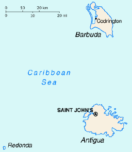 Antigua and Barbuda lies in the eastern arc of the Leeward Islands of
the Lesser Antilles, separating the Atlantic Ocean from the Caribbean
Sea. Antigua is 650 kilometers southeast of Puerto Rico.
Barbuda lies forty-eight kilometers due north of Antigua, and the
uninhabited island of Redonda is fifty-six kilometers southwest of
Antigua. The largest island, Antigua, is 21 kilometers
across and 281 square kilometers in area, or about two-thirds the size
of New York City. Barbuda covers 161 square kilometers, while Redonda
encompasses a mere 2.6 square kilometers. The capital of Antigua and
Barbuda is St. John's, located at St. John's Harbour on the northwest
coast of Antigua. The principal city of Barbuda is Codrington, located
on Codrington Lagoon.
Antigua and Barbuda lies in the eastern arc of the Leeward Islands of
the Lesser Antilles, separating the Atlantic Ocean from the Caribbean
Sea. Antigua is 650 kilometers southeast of Puerto Rico.
Barbuda lies forty-eight kilometers due north of Antigua, and the
uninhabited island of Redonda is fifty-six kilometers southwest of
Antigua. The largest island, Antigua, is 21 kilometers
across and 281 square kilometers in area, or about two-thirds the size
of New York City. Barbuda covers 161 square kilometers, while Redonda
encompasses a mere 2.6 square kilometers. The capital of Antigua and
Barbuda is St. John's, located at St. John's Harbour on the northwest
coast of Antigua. The principal city of Barbuda is Codrington, located
on Codrington Lagoon.