| Cyprus Table of Contents
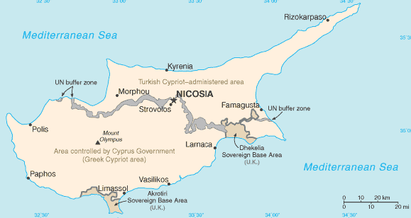
The physical setting for life on the island is dominated by the mountain masses and the central plain they encompass, the Mesaoria. The Troodos Mountains cover most of the southern and western portions of the island and account for roughly half its area. The narrow Kyrenia Range, extending along the northern coastline, occupies substantially less area, and elevations are lower. The two mountain systems run generally parallel to the Taurus Mountains on the Turkish mainland, whose silhouette is visible from northern Cyprus. Coastal lowlands, varying in width, surround the island.
Terrain The rugged Troodos Mountains, whose principal range stretches from Pomos Point in the northwest almost to Larnaca Bay on the east, are the single most conspicuous feature of the landscape. Intensive uplifting and folding in the formative period left the area highly fragmented, so that subordinate ranges and spurs veer off at many angles, their slopes incised by steep-sided valleys. In the southwest, the mountains descend in a series of stepped foothills to the coastal plain. While the Troodos Mountains are a massif formed of molten igneous rock, the Kyrenia Range is a narrow limestone ridge that rises suddenly from the plains. Its easternmost extension becomes a series of foothills on the Karpas Peninsula. That peninsula points toward Asia Minor, to which Cyprus belongs geologically. Even the highest peaks of the Kyrenia Range are hardly more than half the height of the great dome of the Troodos massif, Mount Olympus (1,952 meters), but their seemingly inaccessible, jagged slopes make them considerably more spectacular. British writer Lawrence Durrell, in Bitter Lemons, wrote of the Troodos as "an unlovely jumble of crags and heavyweight rocks" and of the Kyrenia Range as belonging to "the world of Gothic Europe, its lofty crags studded with crusader castles." Rich copper deposits were discovered in antiquity on the slopes of the Troodos. Geologists speculate that these deposits may have originally formed under the Mediterranean Sea, as a consequence of the upwelling of hot, mineral-laded water through a zone where plates that formed the ocean floor were pulling apart. Drainage Deforestation over the centuries has damaged the island's drainage system and made access to a year-round supply of water difficult. A network of winter rivers rises in the Troodos Mountains and flows out from them in all directions. The Yialias River and the Pedhieos River flow eastward across the Mesaoria into Famagusta Bay; the Serraghis River flows northwest through the Morphou plain. All of the island's rivers, however, are dry in the summer. An extensive system of dams and waterways has been constructed to bring water to farming areas. The Mesaoria is the agricultural heartland of the island, but its productiveness for wheat and barley depends very much on winter rainfall; other crops are grown under irrigation. Little evidence remains that this broad, central plain, open to the sea at either end, was once covered with rich forests whose timber was coveted by ancient conquerors for their sailing vessels. The now-divided capital of the island, Nicosia, lies in the middle of this central plain. 
Custom Search
Source: U.S. Library of Congress |