| Indonesia Table of Contents
Indonesia's variations in culture have been shaped--although not specifically determined--by centuries of complex interactions with the physical environment. Although Indonesians are now less vulnerable to the vicissitudes of nature as a result of improved technology and social programs, to some extent their social diversity has emerged from traditionally different patterns of adjustment to their physical circumstances.
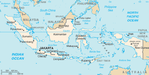
Indonesia is a huge archipelagic country extending 5,120 kilometers from east to west and 1,760 kilometers from north to south. It encompasses 13,667 islands (some sources say as many as 18,000), only 6,000 of which are inhabited. There are five main islands (Sumatra, Java, Kalimantan, Sulawesi, and Irian Jaya), two major archipelagos (Nusa Tenggara and the Maluku Islands), and sixty smaller archipelagos. Two of the islands are shared with other nations; Kalimantan (known in the colonial period as Borneo, the world's third largest island) is shared with Malaysia and Brunei, and Irian Jaya shares the island of New Guinea with Papua New Guinea. Indonesia's total land area is 1,919,317 square kilometers. Included in Indonesia's total territory is another 93,000 square kilometers of inlands seas (straits, bays, and other bodies of water). The additional surrounding sea areas bring Indonesia's generally recognized territory (land and sea) to about 5 million square kilometers. The government, however, also claims an exclusive economic zone, which brings the total to about 7.9 million square kilometers. Geographers have conventionally grouped Sumatra, Java (and Madura), Kalimantan (formerly Borneo), and Sulawesi (formerly Celebes) in the Greater Sunda Islands. These islands, except for Sulawesi, lie on the Sunda Shelf--an extension of the Malay Peninsula and the Southeast Asian mainland. Far to the east is Irian Jaya (formerly Irian Barat or West New Guinea), which takes up the western half of the world's second largest island--New Guinea--on the Sahul Shelf. Sea depths in the Sunda and Sahul shelves average 200 meters or less. Between these two shelves lie Sulawesi, Nusa Tenggara (also known as the Lesser Sunda Islands), and the Maluku Islands (or the Moluccas), which form a second island group where the surrounding seas in some places reach 4,500 meters in depth. The term Outer Islands is used inconsistently by various writers but it is usually taken to mean those islands other than Java and Madura. Tectonically, this region--especially Java--is highly unstable, and although the volcanic ash has resulted in fertile soils, it makes agricultural conditions unpredictable in some areas. The country has numerous mountains and some 400 volcanoes, of which approximately 100 are active. Between 1972 and 1991 alone, twentynine volcanic eruptions were recorded, mostly on Java. The most violent volcanic eruptions in modern times occurred in Indonesia. In 1815 a volcano at Gunung Tambora on the north coast of Sumbawa, Nusa Tenggara Barat Province, claimed 92,000 lives and created "the year without a summer" in various parts of the world. In 1883 Krakatau in the Sunda Strait, between Java and Sumatra, erupted and some 36,000 West Javans died from the resulting tidal wave. The sound of the explosion was reported as far away as Turkey and Japan. For almost a century following that eruption, Krakatau was quiet, until the late 1970s, when it erupted twice. Mountains ranging between 3,000 and 3,800 meters above sea level can be found on the islands of Sumatra, Java, Bali, Lombok, Sulawesi, and Seram. The country's tallest mountains, which reach between 4,700 and 5,000 meters, are located in the Jayawijaya Mountains and the Sudirman Mountains in Irian Jaya. The highest peak, Puncak Jaya, which reaches 5,039 meters, is located in the Sudirman Mountains. Nusa Tenggara consists of two strings of islands stretching eastward from Bali toward Irian Jaya. The inner arc of Nusa Tenggara is a continuation of the chain of mountains and volcanoes extending from Sumatra through Java, Bali, and Flores, and trailing off in the Banda Islands. The outer arc of Nusa Tenggara is a geological extension of the chain of islands west of Sumatra that includes Nias, Mentawai, and Enggano. This chain resurfaces in Nusa Tenggara in the ruggedly mountainous islands of Sumba and Timor. The Maluku Islands (or Moluccas) are geologically among the most complex of the Indonesian islands. They are located in the northeast sector of the archipelago, bounded by the Philippines to the north, Irian Jaya to the east, and Nusa Tenggara to the south. The largest of these islands include Halmahera, Seram, and Buru, all of which rise steeply out of very deep seas. This abrupt relief pattern from sea to high mountains means that there are very few level coastal plains. Geographers believe that the island of New Guinea, of which Irian Jaya is a part, may once have been part of the Australian continent. The breakup and tectonic action created both towering, snowcapped mountain peaks lining its central east-west spine and hot, humid alluvial plains along the coast of New Guinea. Irian Jaya's mountains range some 650 kilometers east to west, dividing the province between north and south. Climate 
Custom Search
Source: U.S. Library of Congress |