| Jordan Table of Contents
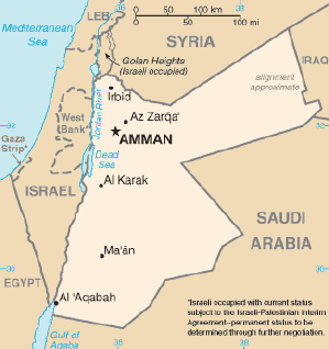 The territory of Jordan covers about 91,880 square kilometers. Until
1988, when King Hussein relinquished Jordan's claim to the West Bank,
that area was considered part of Jordan, although only officially
recognized as such by Britain and Pakistan. At that time the West
Bank--which encompasses about 5,880 square kilometers--had been under
Israeli occupation since the June 1967 War between Israel and the states
of Egypt, Jordan, and Syria. The territory of Jordan covers about 91,880 square kilometers. Until
1988, when King Hussein relinquished Jordan's claim to the West Bank,
that area was considered part of Jordan, although only officially
recognized as such by Britain and Pakistan. At that time the West
Bank--which encompasses about 5,880 square kilometers--had been under
Israeli occupation since the June 1967 War between Israel and the states
of Egypt, Jordan, and Syria.
Jordan is landlocked except at its southern extremity, where nearly
twenty-six kilometers of shoreline along the Gulf of Aqaba provide
access to the Red Sea. A great north-south geological rift, forming the
depression of Lake Tiberias (Sea of Galilee), the Jordan Valley, and the
Dead Sea, is the dominant topographical feature.
Boundaries
Topography
Climate
Source: U.S. Library of Congress
|
