| Nicaragua Table of Contents
The Pacific lowlands extend about 75 kilometers inland from the Pacific coast. Most of the area is flat, except for a line of young volcanoes, many of which are still active, running between the Golfo de Fonseca and Lago de Nicaragua. These peaks lie just west of a large crustal fracture or structural rift that forms a long, narrow depression passing southeast across the isthmus from the Golfo de Fonseca to the Río San Juan. The rift is occupied in part by the largest freshwater lakes in Central America: Lago de Managua (56 kilometers long and 24 kilometers wide) and Lago de Nicaragua (about 160 kilometers long and 75 kilometers wide). These two lakes are joined by the Río Tipitapa, which flows south into Lago de Nicaragua. Lago de Nicaragua in turn drains into the Río San Juan (the boundary between Nicaragua and Costa Rica), which flows through the southern part of the rift lowlands to the Caribbean Sea. The valley of the Río San Juan forms a natural passageway close to sea level across the Nicaraguan isthmus from the Caribbean Sea to Lago de Nicaragua and the rift. From the southwest edge of Lago de Nicaragua, it is only nineteen kilometers to the Pacific Ocean. This route was considered as a possible alternative to the Panama Canal at various times in the past. Surrounding the lakes and extending northwest of them along the rift valley to the Golfo de Fonseca are fertile lowland plains highly enriched with volcanic ash from nearby volcanoes. These lowlands are densely populated and well cultivated. More directly west of the lake region is a narrow line of ash-covered hills and volcanoes that separate the lakes from the Pacific Ocean. This line is highest in the central portion near León and Managua. Because western Nicaragua is located where two major tectonic plates collide, it is subject to earthquakes and volcanic eruptions. Although periodic volcanic eruptions have caused agricultural damage from fumes and ash, earthquakes have been by far more destructive to life and property. Hundreds of shocks occur each year, some of which cause severe damage. The capital city of Managua was virtually destroyed in 1931 and again in 1972. The triangular area known as the central highlands lies northeast and east of the Pacific lowlands. This rugged mountain terrain is composed of ridges 900 to 1,800 meters high and a mixed forest of oak and pine alternating with deep valleys that drain primarily toward the Caribbean. Very few significant streams flow west to the Pacific Ocean; those that do are steep, short, and flow only intermittently. The relatively dry western slopes of the central highlands, protected by the ridges of the highlands from the moist winds of the Caribbean, have drawn farmers from the Pacific region since colonial times and are now well settled. The eastern slopes of the highlands are covered with rain forests and are lightly populated with pioneer agriculturalists and small communities of indigenous people. The eastern Caribbean lowlands of Nicaragua form the extensive (occupying more than 50 percent of national territory) and still sparsely settled lowland area known as Costa de Mosquitos. The Caribbean lowlands are sometimes considered synonymous with the former department of Zelaya, which is now divided into the North Atlantic Autonomous Region (Región Autonomista Atlántico Norte) and the South Atlantic Autonomous Region (Región Autonomista Atlántico Sur) and constitutes about 45 percent of Nicaragua's territory. These lowlands are a hot, humid area that includes coastal plains, the eastern spurs of the central highlands, and the lower portion of the Río San Juan basin. The soil is generally leached and infertile. Pine and palm savannas predominate as far south as the Laguna de Perlas. Tropical rain forests are characteristic from the Laguna de Perlas to the Río San Juan, in the interior west of the savannas, and along rivers through the savannas. Fertile soils are found only along the natural levees and narrow floodplains of the numerous rivers, including the Escondido, the Río Grande de Matagalpa, the Prinzapolka, and the Coco, and along the many lesser streams that rise in the central highlands and cross the region en route to the complex of shallow bays, lagoons, and salt marshes of the Caribbean coast. 
Custom Search
Source: U.S. Library of Congress |
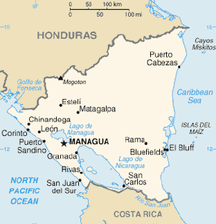 Nicaragua, approximately the size of New York state, is the largest
country in Central
America. The country covers a total area of 129,494
square kilometers (120,254 square kilometers of which are land area) and
contains a diversity of climates and terrains. The country's physical
geography divides it into three major zones: Pacific lowlands, the
wetter, cooler central highlands, and the Caribbean lowlands.
Nicaragua, approximately the size of New York state, is the largest
country in Central
America. The country covers a total area of 129,494
square kilometers (120,254 square kilometers of which are land area) and
contains a diversity of climates and terrains. The country's physical
geography divides it into three major zones: Pacific lowlands, the
wetter, cooler central highlands, and the Caribbean lowlands.