| Saudi Arabia Table of Contents
Saudi Arabia is bounded by seven countries and three bodies of water. To the west, the Gulf of Aqaba and the Red Sea form a coastal border of almost 1,800 kilometers that extends south to Yemen and follows a mountain ridge for approximately 320 kilometers to the vicinity of Najran. This section of the border with Yemen was demarcated in 1934 and is one of the few clearly defined borders with a neighboring country. The Saudi border running southeast from Najran, however, is still undetermined. The undemarcated border became an issue in the early 1990s, when oil was discovered in the area and Saudi Arabia objected to the commercial exploration by foreign companies on behalf of Yemen. In the summer of 1992, representatives of Saudi Arabia and Yemen met in Geneva to discuss settlement of the border issue. To the north, Saudi Arabia is bounded by Jordan, Iraq, and Kuwait. The northern boundary extends almost 1,400 kilometers from the Gulf of Aqaba on the west to Ras al Khafji on the Persian Gulf. In 1965 Saudi Arabia and Jordan agreed to boundary demarcations involving an exchange of small areas of territory that gave Jordan some essential additional land near Aqaba, its only port. In 1922 Abd al Aziz ibn Abd ar Rahman Al Saud (r. 1902-53) and British officials representing Iraqi interests signed the Treaty of Mohammara, which established the boundary between Iraq and the future Saudi Arabia. Later that year, the Al Uqair Convention signed by the two parties agreed to the creation of a diamond-shaped Iraq-Saudi Arabia Neutral Zone of approximately 7,000 square kilometers, adjacent to the western tip of Kuwait, within which neither Iraq nor Saudi Arabia would build permanent dwellings or installations. The agreement was designed to safeguard water rights in the zone for beduin of both countries. In May 1938, Iraq and Saudi Arabia signed an additional agreement regarding the administration of the zone. Forty-three years later, Saudi Arabia and Iraq signed an agreement that defined the border between the two countries and provided for the division of the neutral zone between them. The agreement effectively dissolved the neutral zone. The boundary between Abd al Aziz's territories of Najd and the Eastern Province and the British protectorate of Kuwait was first regulated by the Al Uqair Convention in 1922. In an effort to avoid territorial disputes, another diamond-shaped Divided Zone of 5,790 square kilometers directly south of Kuwait was established. In 1938 oil was discovered in Kuwait's southern Burqan fields, and both countries contracted with foreign oil companies to perform exploration work in the Divided Zone. After years of discussions, Saudi Arabia and Kuwait reached an agreement in 1965 that divided the zone geographically, with each country administering its half of the zone. The agreement guaranteed that the rights of both parties to the natural resources in the whole zone would continue to be respected after each country had annexed its half of the zone in 1966. Saudi Arabia's eastern boundary follows the Persian Gulf from Ras al Khafji to the peninsula of Qatar, whose border with Saudi Arabia was determined in 1965. The Saudi border with the state of Oman, on the southeastern coast of the Arabian Peninsula, runs through the Empty Quarter (Rub al Khali). The border demarcation was defined by a 1990 agreement between Saudi Arabia and Oman that included provisions for shared grazing rights and use of water resources. The border through Al Buraymi Oasis, located near the conjunction of the frontiers of Oman, Abu Dhabi (one of the emirates of the UAE), and Saudi Arabia, has triggered extensive dispute among the three states since the Treaty of Jiddah in 1927. In a 1975 agreement with Saudi Arabia, Abu Dhabi accepted sovereignty over six villages in the Al Buraymi Oasis and the sharing of the rich Zararah oil field. In return, Saudi Arabia obtained an outlet to the Persian Gulf through Abu Dhabi. Saudi Arabia's maritime claims include a twelve-nautical-mile territorial limit along its coasts. The Saudis also claim many small islands as well as some seabeds and subsoils beyond the twelve-nautical-mile limit.
Topography and Natural Regions 
Custom Search
Source: U.S. Library of Congress |
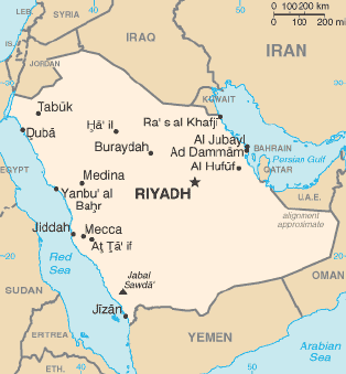 The kingdom occupies 80 percent of the Arabian Peninsula. Most of the
country's boundaries with the United Arab Emirates (UAE), Oman, and the
Republic of Yemen (formerly two separate countries: the Yemen Arab
Republic, or North Yemen; and the People's Democratic Republic of Yemen,
or South Yemen) are undefined, so the exact size of the country remains
unknown. The Saudi government estimate is 2,217,949 square kilometers.
Other reputable estimates vary between 2,149,690 square kilometers and
2,240,000 square kilometers. Less than 1 percent of the total area is
suitable for cultivation, and in the early 1990s population distribution
varied greatly among the towns of the eastern and western coastal areas,
the densely populated interior oases, and the vast, almost empty
deserts.
The kingdom occupies 80 percent of the Arabian Peninsula. Most of the
country's boundaries with the United Arab Emirates (UAE), Oman, and the
Republic of Yemen (formerly two separate countries: the Yemen Arab
Republic, or North Yemen; and the People's Democratic Republic of Yemen,
or South Yemen) are undefined, so the exact size of the country remains
unknown. The Saudi government estimate is 2,217,949 square kilometers.
Other reputable estimates vary between 2,149,690 square kilometers and
2,240,000 square kilometers. Less than 1 percent of the total area is
suitable for cultivation, and in the early 1990s population distribution
varied greatly among the towns of the eastern and western coastal areas,
the densely populated interior oases, and the vast, almost empty
deserts.