| South Africa Table of Contents
South Africa forms a distinct region, or subcontinent, divided from the rest of Africa by the rivers that mark its northern border. In the northwest, the Orange River cuts through the Namib Desert and divides South Africa from Namibia. In the east, the Limpopo River traverses large areas of arid grassland along the common border with Zimbabwe and southeastern Botswana. Between these two, the Molopo River winds through the southern basin of the Kalahari Desert, also dividing South Africa from Botswana. Populations have moved across these rivers almost continuously over the centuries, but, in general, the northern border region of South Africa is sparsely populated. The geological substratum of the subcontinent was formed at least 3.8 billion years ago, according to geologists, and most of the country's natural features evolved into their present form more than 200 million years ago. Especially since the early twentieth-century writings of Alfred Wegener, geologists have hypothesized that South Africa was once part of a large land mass, now known as Gondwana, or Gondwanaland, that slowly fractured along the African coastline millions of years ago. Theories of such a supercontinent are bolstered by geological continuities and mineral similarities between South Africa and South America, by fossil similarities between South Africa and the Indian Ocean island of Madagascar, and by the sharp escarpments, or geological fractures, that encircle most of southern Africa near the coast. The ancient rock substratum is overlain by sedimentary and volcanic rock formations. Because ground cover is sparse, only about 11 percent of the land in South Africa is arable. More than 20 percent of the land is too arid or the soil is too poor for any agricultural activity without irrigation; roughly 66 percent is suitable only for livestock grazing. Even the thin soil cover has been severely eroded, especially in the country's most overpopulated and impoverished rural areas. The relatively poor land conceals enormous wealth in minerals, however, including gold, diamonds, copper, platinum, asbestos, and coal.
Geographic Regions 
Custom Search
Source: U.S. Library of Congress |
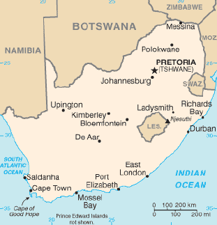 South Africa occupies the southern tip of the African continent,
stretching from 22°S to 35°S latitude and from 17°E to 33°E
longitude. The northeastern corner of the country lies within the
tropics, astride the Tropic of Capricorn. South Africa covers 1.2
million square kilometers of land, one-seventh the area of the United
States, or roughly twice the area of Texas. Nearly 4,900 kilometers of
international boundaries separate South Africa from Namibia, Botswana,
Zimbabwe, Mozambique, and Swaziland--from northwest to northeast--and
South Africa completely surrounds the small nation of Lesotho. In
addition, the 2,881-kilometer coastline borders the Atlantic Ocean on
the west and the Indian Ocean on the south and east. South Africa's
extraterritorial holdings include Robben Island, Dassen Island, and Bird
Island in the Atlantic Ocean, and Prince Edward Island and Marion Island
about 1,920 kilometers southeast of Cape Town in the Indian Ocean.
Marion Island, at 46°S latitude, is the site of an important weather
research station.
South Africa occupies the southern tip of the African continent,
stretching from 22°S to 35°S latitude and from 17°E to 33°E
longitude. The northeastern corner of the country lies within the
tropics, astride the Tropic of Capricorn. South Africa covers 1.2
million square kilometers of land, one-seventh the area of the United
States, or roughly twice the area of Texas. Nearly 4,900 kilometers of
international boundaries separate South Africa from Namibia, Botswana,
Zimbabwe, Mozambique, and Swaziland--from northwest to northeast--and
South Africa completely surrounds the small nation of Lesotho. In
addition, the 2,881-kilometer coastline borders the Atlantic Ocean on
the west and the Indian Ocean on the south and east. South Africa's
extraterritorial holdings include Robben Island, Dassen Island, and Bird
Island in the Atlantic Ocean, and Prince Edward Island and Marion Island
about 1,920 kilometers southeast of Cape Town in the Indian Ocean.
Marion Island, at 46°S latitude, is the site of an important weather
research station.