| Lithuania Table of Contents
Lithuania's northern neighbor is Latvia. The two countries share a border that extends 453 kilometers. Lithuania's eastern border with Belarus is longer, stretching 502 kilometers. The border with Poland on the south is relatively short, only ninety-one kilometers, but is very busy because of international traffic. Lithuania also has a 227-kilometer border with Russia. Russian territory adjacent to Lithuania is Kaliningrad Oblast, which is the northern part of the former German East Prussia, including the city of Kaliningrad. Finally, Lithuania has 108 kilometers of Baltic seashore with an ice-free harbor at Klaipeda. The Baltic coast offers sandy beaches and pine forests and attracts thousands of vacationers. Topography,
Drainage, and Climate 
Custom Search
Source: U.S. Library of Congress |
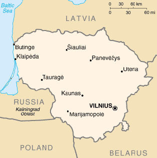 Lithuania is situated on the eastern shore of the Baltic Sea.
Lithuania's boundaries have changed several times since 1918, but they
have been stable since 1945. Currently, Lithuania covers an area of
about 65,200 square kilometers. About the size of West Virginia, it is
larger than Belgium, Denmark, the Netherlands, or Switzerland.
Lithuania is situated on the eastern shore of the Baltic Sea.
Lithuania's boundaries have changed several times since 1918, but they
have been stable since 1945. Currently, Lithuania covers an area of
about 65,200 square kilometers. About the size of West Virginia, it is
larger than Belgium, Denmark, the Netherlands, or Switzerland.